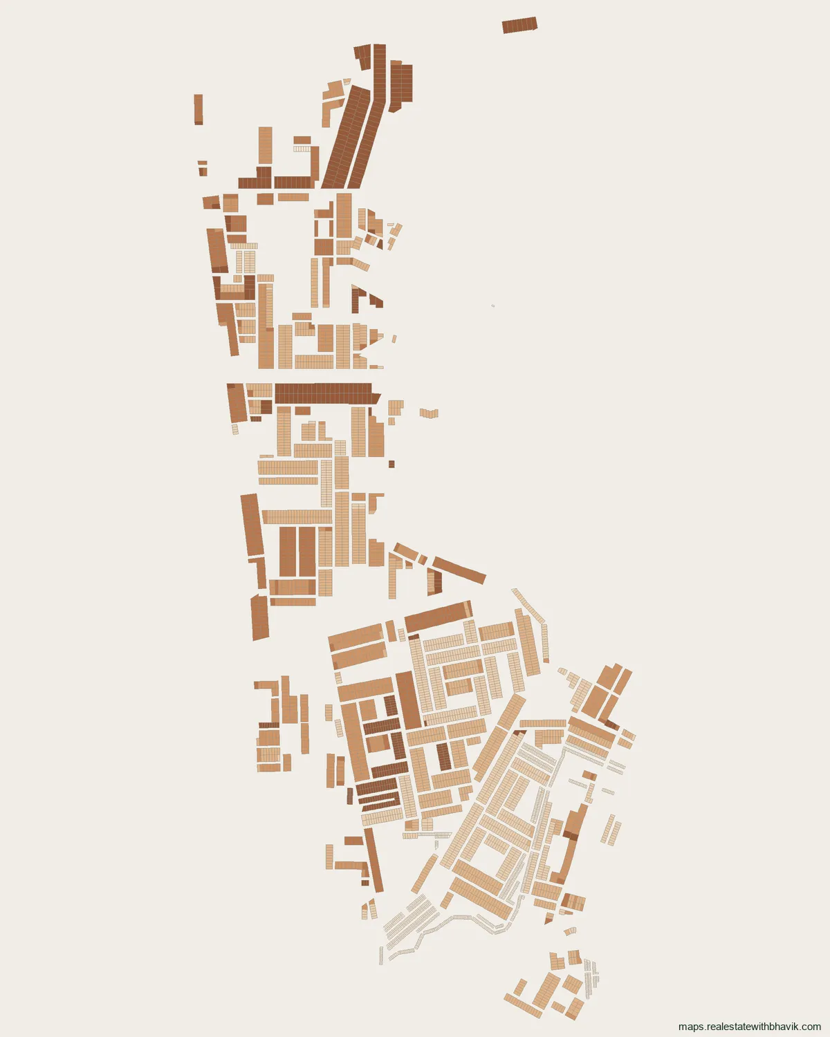
Tap any plot for its number, recorded size and dimensions, licence details, corner and park-facing status, and its Google Maps location with directions. The buttons on the map switch each plot type on or off.
Find a plot
Pick HSVP plots, a licensed colony block or commercial plots, then start typing the plot number.
Layout picture, to save or share
At a glance
- Plots
- 5,039on GMDA's licensed-plot layer
- Plot sizes
- 51 to 680 sq m
- Licence
- 62 of 2007 and 302 of 2005Ansal Properties & Infrastructure
- Area
- MG Road & Golf Course Roadcorridor
- Nearest metro
- Millennium City Centre GurugramYellow Line, 0.8 km
- Pin code
- 122009India Post
About this colony
GMDA's planning data maps 5,039 plots in Ansal Properties & Infrastructure licensed colony, Sector 27, 28, 43 and 53. The DTCP licence record for this colony (case LC-3, licence 62 of 2007 and 302 of 2005) names Ansal Properties & Infrastructure as developer and covers about 185 acres. Its plots spread over Sector 43 (3,274), Sector 27 (845), Sector 28 (756) and Sector 53 (164).
In Ansal Properties & Infrastructure licensed colony, Sector 27, 28, 43 and 53, residential plots run from 51 to 680 sq m, 250 sq m being the most frequent. On completion, GMDA's licence layer for Ansal Properties & Infrastructure licensed colony, Sector 27, 28, 43 and 53 reads: no completion recorded in gmda's data. Millennium City Centre Gurugram on the Yellow Line is the nearest metro to Ansal Properties & Infrastructure licensed colony, Sector 27, 28, 43 and 53, about 0.8 km away. From Ansal Properties & Infrastructure licensed colony, Sector 27, 28, 43 and 53, Golf Course Road is 1.4 km away and NH-48 (Delhi-Jaipur highway) is 2.4 km away, as the crow flies. Ansal Properties & Infrastructure licensed colony, Sector 27, 28, 43 and 53 uses pin code 122009.
Before you pay a token for a plot in Ansal Properties & Infrastructure licensed colony, Sector 27, 28, 43 and 53, ask us to check it against the licence boundary and the plan.
Licence
Licence details for Ansal Properties & Infrastructure licensed colony, Sector 27, 28, 43 and 53
- Developer (licence record)
- Ansal Properties & Infrastructure
- Licence
- 62 of 2007 and 302 of 2005
- DTCP case
- LC-3
- Licensed area
- about 185 acres
- Licence year
- 1985, 1986, 1987, 1989, 1992, 1993, 1995, 1996, 1997, 1998, 2001, 2004, 2007 and 2011
- Purpose
- Residential plotted colony
- Completion
- No completion recorded in GMDA's data
From GMDA's licence layer. A licence on the map is not proof of title; ask for the licence and the sale deed chain.
What is in Ansal Properties & Infrastructure licensed colony, Sector 27, 28, 43 and 53
5,039 plots in GMDA's published planning data, as that data records them.
| Size | Plots |
|---|---|
| 250 sq m | 1,261 |
| 180 sq m | 1,025 |
| 51 sq m | 887 |
| 350 sq m | 461 |
| 680 sq m | 334 |
| 420 sq m | 292 |
| 348 sq m | 62 |
| 60 sq m | 55 |
| 300 sq m | 54 |
| 200 sq m | 35 |
| Category | Plots |
|---|---|
| Licensed colony plots | 5,039 |
| Block or plot group | Residential plots | All parcels | Size range | Most common size |
|---|---|---|---|---|
| A | 735 | 735 | 45 to 1,160 sq m | 250, 350, 420 sq m |
| B | 828 | 828 | 171 to 1,068 sq m | 250, 420 sq m |
| C | 1,366 | 1,366 | 51 to 680 sq m | 180, 250, 680 sq m |
| C1 | 1,573 | 1,574 | 33 to 714 sq m | 51, 180, 250 sq m |
| C2 | 226 | 226 | 80 to 645 sq m | 180, 250, 348 sq m |
| D | 104 | 104 | 190 to 680 sq m | 250, 330, 350 sq m |
| E | 168 | 168 | 36 to 382 sq m | 51, 250 sq m |
| Licensed colony plots | 38 | 38 | 50 to 898 sq m | 225, 299 sq m |
Around Ansal Properties & Infrastructure licensed colony, Sector 27, 28, 43 and 53
Distances are straight lines from the middle of the colony; road distances are longer.
Metro
- Millennium City Centre Gurugram about 0.8 km, Yellow Line
- Sector 42-43 about 1.6 km, Rapid Metro
- IFFCO Chowk about 1.7 km, Yellow Line
- DLF Phase 1 about 1.9 km, Rapid Metro
Schools and colleges
- Stones2milestones about 0.6 km
- Amity School about 0.6 km
- Excelsior American School about 0.8 km
Hospitals
- Max Hospital about 0.7 km
- Fortis Memorial Research Institute / Fortis Vivekanand Hospital about 0.8 km
- Sitaram Bhartia about 1.0 km
Malls and markets
- ROF Portico about 0.6 km
- Gold Souk about 0.9 km
- DLF Galleria about 1.0 km
Roads, Cyber City and airport
- Golf Course Road about 1.4 km
- NH-48 (Delhi-Jaipur highway) about 2.4 km
- DLF Cyber City about 4.4 km
- Golf Course Extension Road about 4.7 km
- Sohna Road about 4.9 km
- Dwarka Expressway about 8.5 km
Pin code
Ansal Properties & Infrastructure licensed colony, Sector 27, 28, 43 and 53 uses pin code 122009, from GMDA's pin-code map and listed by India Post for offices including Galleria DLF-IV.
Ansal Properties & Infrastructure licensed colony, Sector 27, 28, 43 and 53, answered
Who developed Ansal Properties & Infrastructure licensed colony, Sector 27, 28, 43 and 53?
The DTCP licence record names Ansal Properties & Infrastructure.
What is the licence number of Ansal Properties & Infrastructure licensed colony, Sector 27, 28, 43 and 53?
Licence 62 of 2007 and 302 of 2005, DTCP case LC-3, as GMDA's licence layer records it.
How many plots are in Ansal Properties & Infrastructure licensed colony, Sector 27, 28, 43 and 53?
5,039 plots on GMDA's licensed-plot layer, sized 51 to 680 sq m.
Which sector is Ansal Properties & Infrastructure licensed colony, Sector 27, 28, 43 and 53 in?
Sector 43, Sector 27, Sector 28 and Sector 53, in the MG Road & Golf Course Road area of Gurgaon.
Has Ansal Properties & Infrastructure licensed colony, Sector 27, 28, 43 and 53 received completion?
GMDA's licence layer records: no completion recorded in gmda's data. Ask the developer for the completion certificate.
What is the pin code of Ansal Properties & Infrastructure licensed colony, Sector 27, 28, 43 and 53?
Ansal Properties & Infrastructure licensed colony, Sector 27, 28, 43 and 53 uses pin code 122009, from GMDA's pin-code map and listed by India Post for offices including Galleria DLF-IV.
Talk to us
Ask about any plot in Ansal Properties & Infrastructure licensed colony, Sector 27, 28, 43 and 53
Quickest by WhatsApp or a call. We answer questions about specific plots, corner status, and paperwork.
Would rather not call?
Leave your details and we will come back to you.
Message received
Sectors in MG Road & Golf Course Road
See every published map on the Gurgaon sector maps page.